In order to implement Ring City, planners would have to utilize much of the Duany and Plater-Zyberk arsenal: mixed-use instead of single-use zoning; visual planning guidelines to supplement written codes; and a clear distinction between different kinds of public and private spaces in the region. But the heart of the Ring City, its Urban Ring, would also involve some additional characteristics.


The most important characteristic of an Urban Ring would be adaptability.
Because of its synthetic mission—to rejoin the disparate landscapes that
separate city and suburb—it must be able to connect to a wide variety
of existing spatial conditions. It must have a strong enough organizational
"spine" to serve as a generator in areas where little coherent urban
pattern exists. As an example of how a Urban Ring might weave its way
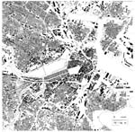
through these different conditions, consider the figure/ground plan of
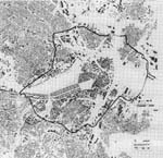
the entire Boston region (figure 12) and how an Urban Ring might tie together
the many districts now clearly separated in that area (figure 13).
Obviously, there would also be many instances in which a segment of an Urban
Ring would be laid on top of substantial urban density. Out of necessity,
then, its urban design guidelines would be composed of a "kit
of parts."![]()
The most consistent element of this kit would be transportation. In most places an Urban Ring would be composed of a broad boulevard with dedicated lanes of circumferential rail or bus lines, transit stations at the intersections of the ring with arterial roads, and high-capacity parking structures. This is the essential transportation skeleton of an Urban Ring. It is what transportation planners call an "intermodal" idea. The boulevard becomes a transfer point for different transit modes: pedestrians, bicyclists, automobiles, buses, and local and commuter trains. Suburban commuters can access its automobile garages from the arterial roads that connect it with the interstate highway beltways or bypasses that surround most cities. They can then transfer onto public transportation moving either around, or into, the city center. Residents of neighborhoods along the Urban Ring can also gain speedy access to the entire region.
It would be preferable for the circumferential transit system to be at grade, so that its dedicated track would be visible as a marker whether a transit vehicle was present or not. Though subways are faster, they are unable to play this crucial role in urban orientation. The urban design guidelines for an Urban Ring would also play a significant role in orientation and "forming a mental map" of the city.
The continuity that is essential for a transportation line is also
essential from an urban design perspective for an Urban Ring. It should
have a continuous identity throughout the region, thus making deviations
from this common "thread" more meaningful. The strictest
guidelines would hold closest to the Urban Ring itself.![]() Consistent building
heights and alignmets would be required for sites defining both the inside and outside of an Urban Ring.
This continuous spatial enclosure would ensure the experience of circumferential
movement along the route. There could also be towers marking the major
intersections and intermodal stations. These towers might have tall light
poles extending high into the air so that at night, the Urban Ring could
be seen from a great distance. This image of a ring of light around
the city offers another bridge in scale between the local and the regional.
Consistent building
heights and alignmets would be required for sites defining both the inside and outside of an Urban Ring.
This continuous spatial enclosure would ensure the experience of circumferential
movement along the route. There could also be towers marking the major
intersections and intermodal stations. These towers might have tall light
poles extending high into the air so that at night, the Urban Ring could
be seen from a great distance. This image of a ring of light around
the city offers another bridge in scale between the local and the regional.
The mixed-use buildings defining the edge of the boulevard would be quite thin, so as to reinforce their reading as spacial containers. In some cases, such as with hybrids of housing and ground-floor retail, this would be the extent of the building's depth. But other types, such as large-scale retail (a supermarket, for example), would have their thin dimension serve as an entry zone with offices above, while the rear portion of the building dropped to a more typical commercial height. Civic buildings would be the only ones to pull back from the consistent street edge, and it would be desirable for them to occur at entrances to identifiable neighborhoods so that they could serve as community links to the Urban Ring. The remaining features of the boulevard would be trees planted on one or both sides (depending on the available dimension) and consistently designed kiosks for police, information, and communication services.
These parts would be deployed in their entirety when possible, and they
would serve as examples for building renovation where existing conditions
were to be altered. But the spatial principles would remain consistent
throughout: continuity, circumferential experience, civic hierarchy, and
legibility.![]()