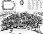
The history of centralized town planning is long and we need not review all of it here, but two specific aspects are particularly relevant to the fragmentation facing America's metropolitan areas today. One is the ideal city, or the city designed to represent a specific social or religious order. The other, often a related type, is the walled city of military fortification.
An ideal city, in the words of Spiro Kostoff, "engraves a pattern of faith and government."9 The city becomes a diagram that articulates social order and hierarchy. It does so by clearly defining some spaces as more important than others. The center, key nodes, gates, etc., are all participants in a spatial order that is understandable to the inhabitants because it is reconciled with religious, civil, or military arrangements existing among them. Public spaces were clearly distinguished from private spaces; major routes from minor ones; and the sacred is kept distinct from the profane. The identity of the town is the edifice of the wall, coupled perhaps with the silhouette of its major building. So monarchies and holy cities are often planned centrally, because the structure of the society that they are designed to reflect is quite clear.
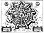

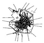
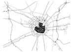
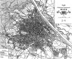
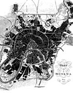
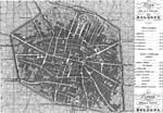
As the need for these fortifications waned, many were torn down and replaced with what we now call ring roads. Moscow, Paris, and Bologna are just a few examples of cities whose former defensive military perimeters evolved into major transportation infrastructure locations (figures 5–7). "In the old fortified cities, the walls were pulled down and converted into a continuous ringroad, while former direct approaches from the countryside were rationalized into straight radial roads linking the fattened suburban belt with the center."10 Trains, carriages, trolleys, buses, automobiles, cyclists, and pedestrians all traveled along these ring roads. In many cases, though, they also served as the location for new kinds of building. Museums, concert halls, cultural attractions, and other developments of bourgeois society soon filled this zone between the old and the new city. Perhaps the best example of this is in Vienna, on the Ringstrasse.

The other important aspect of the history of centrally planned cities
and towns is their role in modern socialist and utopian visions: the ideal
cities of our time. Charles Fourier's phalansteries were designed
to house "2000 people of all races, classes, sexes, and ages," according
to Spiro Kostoff. His City of Garantism was composed of concentric
rings of commercial, industrial, and agricultural zones. This kind of city
in relation to diagrammatic social order reached its high point with Ebenezer
Howard in his 1898 book, Tomorrow: A Peaceful Path to Social Reform.11
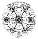
His diagram of the "Group of Slumless Smokeless Cities" and his plans for
the Garden City were strong evidence of his faith in the relationship
of geometry and order to social reform (figure 10). Kostoff describes Howard's
view of the Garden City as "an ideally balanced human environment
where town and country met," and quotes Howard ![]() speaking of its attractions: "beauty of nature; social opportunity; fields
and parks of easy access; low rents; high wages; low rates; plenty to do;
low prices; no sweating; pure air and water; bright homes and gardens;
no smoke; no slums; freedom; cooperation." But a particularly interesting
aspect of these utopian communities from our perspective is that they were
designed to maintain a relatively low density. Their goal was to achieve
a socially harmonious relationship between people and nature by resisting
excessive urbanization. We are now faced with precisely the opposite problem:
our cities are losing their density, and we are hoping to use aspects of
these centrally planned utopias to reurbanize them.
speaking of its attractions: "beauty of nature; social opportunity; fields
and parks of easy access; low rents; high wages; low rates; plenty to do;
low prices; no sweating; pure air and water; bright homes and gardens;
no smoke; no slums; freedom; cooperation." But a particularly interesting
aspect of these utopian communities from our perspective is that they were
designed to maintain a relatively low density. Their goal was to achieve
a socially harmonious relationship between people and nature by resisting
excessive urbanization. We are now faced with precisely the opposite problem:
our cities are losing their density, and we are hoping to use aspects of
these centrally planned utopias to reurbanize them.
